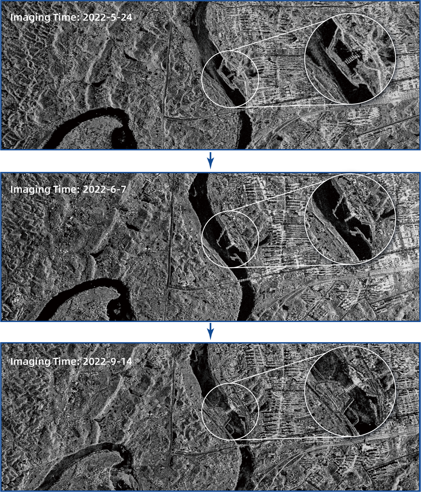
Acquisition modes of SAR satellite:
Spotlight mode (SP) is a high-resolution acquisition mode. In this mode the synthetic aperture antenna, whose beam pointing is always directed towards the object, observes the object for a long period of time, obtains a long synthetic aperture and thus a high azimuthal resolution. This mode is suitable for fine acquisiton.
Stripmap mode (SM)is a basic satellite-borne SAR operating mode. In this mode, the synthetic aperture antenna's beam pointing is fixed with the satellite's flight direction, and the beam scans a strip area parallel to the flight track and obtains a radar image of the strip area. This acquisiiton mode is suitable for mapping large areas.
ScanSAR mode (ScanSAR) has a large acquisition coverage area. In this mode, the synthetic aperture antenna is scanned along the range direction through the electronic beam control, and multiple beams are used to generate multiple sub-bands in the target area, and the acquisition swath width can be increased by utilizing more antenna beams to achieve the mode of large-strip coverage. This mode is suitable for extremely large area coverage observations.
The Terrain Observation by Progressive Scans SAR mode (TOPSAR) adjusts the scanning azimuth and pitch angles of the beam to achieve interleaved scanning between multiple sub-bands, in order to obtain a larger swath width.
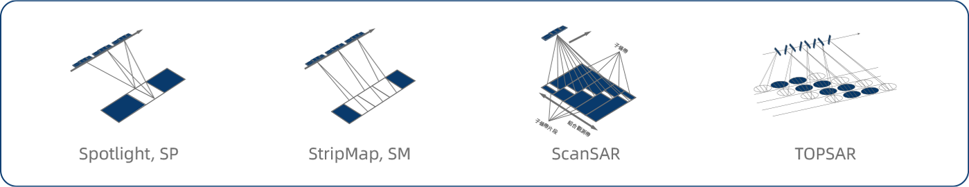
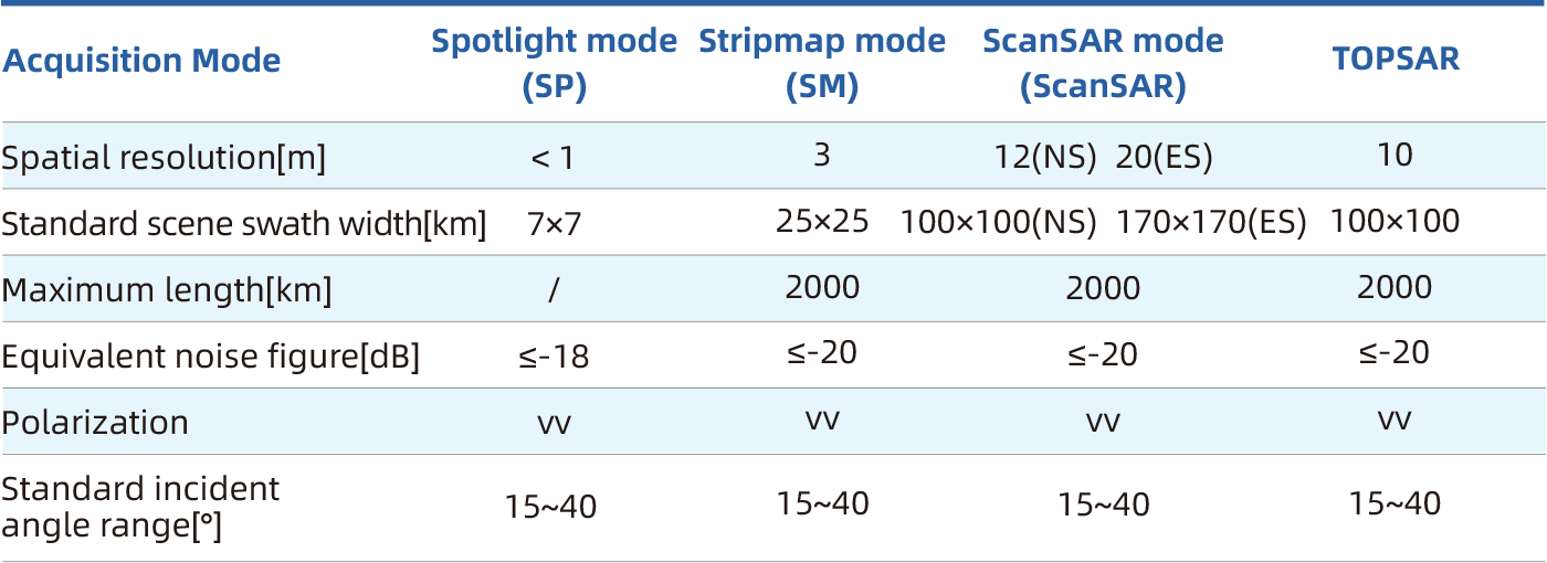
Image product summary
The standard image products of SAR satellites are divided into two categories: primary products (Single Look Complex, SLC) and secondary products (Ortho-rectified image products, ORG).
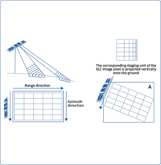
Single Look Complex (SLC) product
SLC products represent slant range images acquired by satellite data acquisition planes. Each pixel of the image is represented by a complex value (I and Q), hence containing both amplitude and phase information. Processing of all Single Look Complex (SLC) products is single-look in each dimension utilizing all available signal bandwidth. Geocoding correction of the imagery is performed using satellite orbit and attitude data.
Orthoscopic Ground Range (ORG) product
ORG products are generated from SLC products through complex data conversion, radiometric correction, and orthorectification using a digital elevation model as the true Earth surface, resulting in L2-level geocoded products. ORG products are amplitude images with encoded information corresponding to latitude and longitude.
The daily order deadline for SAR satellites is before 18:00 Beijing time each day.
Standard order product refers to orders that are completed and confirmed 3 days prior to the client's task acquisition time deadline.This type of order charges no payment for expedited fees.
Medium priority product refers to orders that confirmation is completed 1 day prior to the client's task acquisition time deadline. This type of order charges an expediting fee.
High priority product refers to orders that confirmation is completed 12 hours prior to the client's task acquisition time deadline. This type of order charges an expediting fee.
Log in the PaleblueRS SAR Remote Data Center Service Platform—Images Query Module, to query the data status and purchase.
Standard delivery service: Data website/Baidu Netdisk/FTP/Huawei Cloud/Mobile HDD/CD.
Customization delivery: API interface/Leased data line.
The delivery of data must comply with relevant national laws and regulations for satellite remote sensing data. All users must register in the order system, provide the appropriate unit identification materials or personal information, and pass the verification.